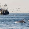
Accidental collisions between ships and whales are a global concern and can occur wherever there is an overlap between whale activity and vessel traffic. Collisions are one of the leading causes of severe injury and death in cetaceans worldwide. It is estimated that around 20,000 cases of fatal ship strikes occur each year. Whales and dolphins spend a large proportion of their time at the ocean’s surface, which makes them particularly vulnerable to collisions with vessels. Whales are more at risk due to their greater size and reduced manoeuvrability. The amount of traffic in the ocean has increased rapidly in recent years, which heightens the risk and the likelihood of ship strikes, especially as shipping lanes overlap with migration routes and key habitats, feeding areas and breeding grounds.
Avoidance is difficult, as vessels often travel at great speeds. They cannot always see whales in their path, and neither can the whales get out of the way fast enough. Oddly, large ships generate a phenomenon called a “bow null effect”, which creates a quiet zone in front of the ship so whales can’t even hear them coming. The most effective way of reducing ship strikes is to separate the vessels from the whales. Speed restrictions can help in zones where segregation is not possible. There are several regulations and prescriptions, from local to international level, which address routing measures, areas with speed restrictions and areas to avoid completely.
The World Shipping Council (WSC) recently launched a new comprehensive global resource, The Whale Chart to help protect whales and dolphins from collisions with ships. This is a free navigational aid, which maps all governmental measures, both mandatory and voluntary, to reduce the harm ships cause to cetaceans. It will be regularly updated as it gives vital information to seafarers, such as coordinates and graphics identifying speed-restricted areas and routing measures, which helps them plan voyages to decrease the chance and occurrence of collisions.